
AI Aerials Toronto: The Most Accurate AI Drone Shot of the CN Tower Yet
Accurate AI aerial footage is science, not luck. The Toronto shots everyone asks for (the CN Tower, the financial district, the waterfront at blue hour) sit in the exact airspace you're least allowed to fly a drone over. So we generate them instead, and validate every frame to within roughly 95% of the real skyline's geometry.
Accurate AI aerial footage is science, not luck. That line is the whole argument of this piece, and the best way to prove it is with the most Toronto problem there is.
Here's the pattern on almost every brief that asks for aerials. The client wants the money shot: the tower against the lake, the dome from directly above, the financial district lighting up at dusk. Then someone checks what it takes to actually fly a drone there, and the shot list quietly shrinks to a park in the suburbs.
The reason is structural, and it's worth understanding before you spend a dollar. The most valuable aerial real estate in the city sits in the airspace that's hardest to legally fly. AI aerials live in that gap. But living in the gap only counts if the footage is real enough to use, which is where the science comes in. First, the gap itself.
The Toronto drone problem, laid out plainly
Two airports define downtown's airspace. Billy Bishop sits right on the Toronto Islands, and its approach paths run out over the harbourfront and the core. Pearson's control zone covers a large stretch to the west. Between them, most of the downtown core and the waterfront fall inside controlled airspace (Toronto drone rules overview).
Flying a drone there legally isn't a matter of being careful. It requires two things: an Advanced RPAS Pilot Certificate from Transport Canada, and a NAV CANADA authorization requested through the NAV Drone app before you take off (NAV Drone, NAV CANADA). Those authorizations are typically processed in one to three business days, sometimes faster for certain airspace classes but never guaranteed. So "we need the shot tomorrow at blue hour" runs straight into a filing queue.
Then there's the ground. Toronto's Municipal Code Chapter 608 bans drones in every city-owned park, and unlike the federal rules it doesn't care about weight class, so even a sub-250g drone you can otherwise fly freely is prohibited (Toronto flying locations). That takes the waterfront parks, the Islands, and most of the green space near the skyline off the table regardless of what certificate you hold. Basic and recreational flying gets pushed out to the city's uncontrolled edges, which is exactly where the skyline isn't.
Put it together and you get the structural gap: the highest-value shot in Toronto is also the one with the most legal friction stacked against it. That's the problem AI aerials actually solve. Not "drones are hard" in the abstract. This specific city, this specific airspace.
What "no drone" actually removes
When nothing physically takes off, a whole column of the production disappears. No Advanced certificate to hold, no NAV Drone authorization to file and wait on, no Chapter 608 exposure, no special flight operations certificate for the trickier requests. Just as important, no weather window. A real skyline flyover is hostage to wind, cloud, and the fifteen-minute band of light you actually want. Miss it and you're rebooking a certified pilot and re-filing airspace. An AI aerial lets you pick the exact hour, dawn, golden, blue, or full night, and produce it on the day you need it, then re-grade it if the brief changes, with no second flight.
That's the honest core of the pitch, and it's a logistics argument before it's a cost one.
The cost comparison, without the spin
I'd rather give you the real numbers than pretend AI is always cheaper. As a general market range in Toronto for 2026, a Transport Canada-certified operator runs roughly CA$150 to $300 for a small set of aerial stills, CA$250 to $600 for a drone-video add-on to a larger shoot, and CA$600 to $1,500 for a full photo/video/drone package; restricted-airspace coordination downtown pushes both the price and the lead time up (Toronto drone pricing, 2026). Those are market figures, not a Cinematechs quote.
Read honestly, that tells you something useful. For a simple suburban lot in open airspace, a certified drone operator is affordable and completely appropriate, and I'd point you to one. The economics flip on the hard shots. The moment the brief is downtown, or in controlled airspace, or tied to a specific light you can't wait around for, the drone route starts absorbing permit fees, coordination time, weather reschedules, and the risk of a re-fly. That's where an AI aerial stops competing on sticker price and starts winning on everything around it. See how our production tiers work →
The part most "AI drone" pitches skip: is it actually accurate?
This is the fair criticism, and I'm not going to dodge it. An AI aerial generator doesn't fly a physical sensor through GPS-tracked space. It predicts plausible motion and geometry from what it learned in training. That's a genuine reason to be skeptical of "AI drone shots" as a category. A lot of what's out there is geometrically mushy: towers that bend, parallax that doesn't add up, a skyline that looks right in a thumbnail and falls apart on a large screen.
So the question isn't whether skepticism is warranted. It is. The question is what a serious studio does about it. Our answer isn't "trust us, it looks real." It's that the generated skyline gets checked against measured data before it ships, the same signal-validated standard we apply across our pipeline, where work is judged by physics rather than by eye. More on that QC standard →
This is where the science line stops being a slogan. Run through the full Cinematechs validation pipeline, a generated Toronto aerial lands within roughly 95% of the real skyline's measured geometry: the tower's height, the spacing between buildings, the footprint of the dome, all matched against reference depth instead of eyeballed. Freehand "AI drone" clips can't say that, and it's the entire difference between footage you can put on a broadcast master and footage you can only put in a fast-scrolling feed.
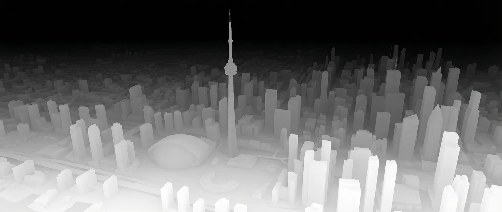
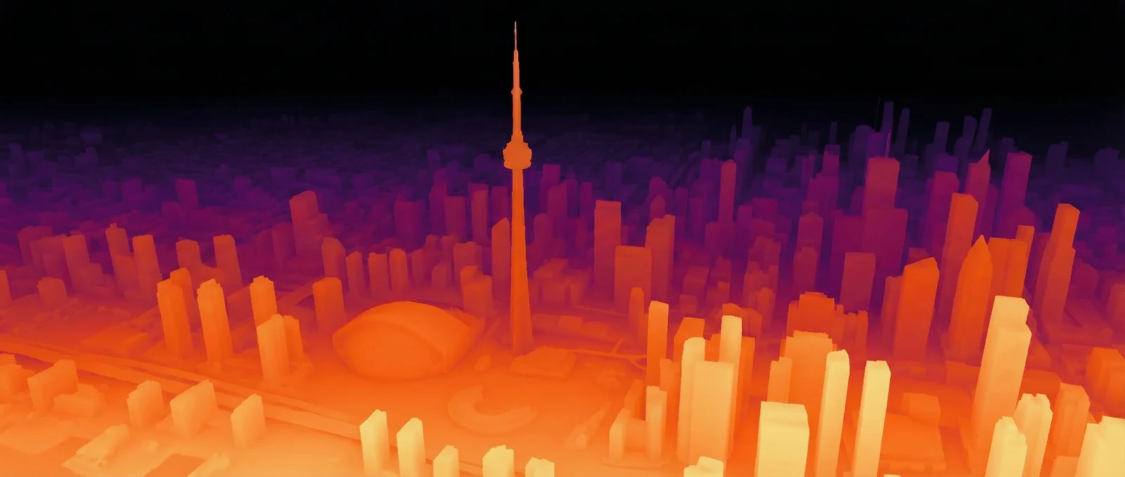
Two passes do most of that work. A depth pass reconstructs the geometry, every structure's relative distance from camera, the tower's height read against the massing around it, so the city is measured, not guessed. A photometric pass checks that light behaves like light: where it falls, how it drops off, whether the glow on a glass face matches the sky it's reflecting. Here's the same Toronto skyline from one of our aerials, seen through both.
How much detail actually survives
Geometry and light checking out is one thing. The other question every skeptic asks is whether the fine detail holds when you push in, or whether it dissolves into mush the moment you leave the wide shot. So here it is, pushed in. These are tight crops straight off the same master.
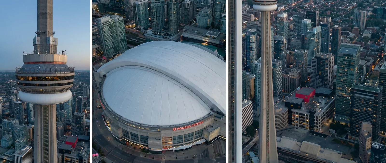
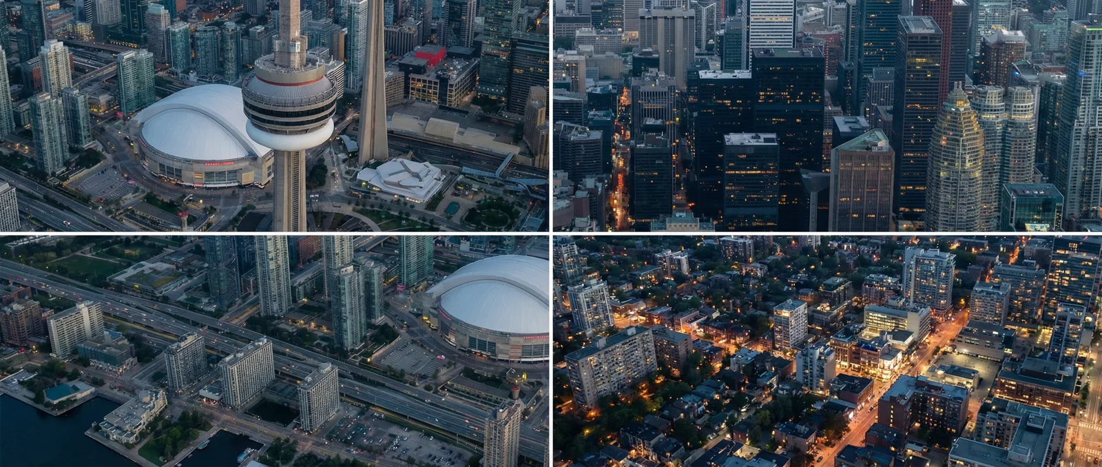
None of this claims an AI aerial is identical to footage a physical drone captured. It isn't, and pretending otherwise would be the exact dishonesty the skeptics are right to call out. What it does claim is narrower and defensible: the geometry and the lighting were held to a measurable standard, that roughly 95% match, so the shot holds up where it matters, on a broadcast master, a sales-gallery wall, or a cinema screen, instead of only in a social crop.
When an AI aerial is the right call in Toronto
It comes down to the shot, not ideology. If you need a clean aerial of a suburban property in open airspace on a clear day, hire a certified drone operator. If you need the downtown skyline, a specific building read against the CN Tower, a particular hour of light, a night flyover, or the same establishing shot re-graded three times as a campaign evolves, the AI route removes the airspace, the wait, and the re-fly, and keeps the geometry honest while it does. That's the case for it, laid out straight. See the delivered work →
Need a Toronto skyline shot the airspace won't let you fly? Tell us the building, the angle, and the hour, and we'll come back with a plan within one business day.
Book a call ↗ See the studio & pipelineFAQ
Do you need a permit to fly a drone over downtown Toronto?
For most of the downtown core and waterfront, yes. Billy Bishop and Pearson put that airspace under control, so legally flying there needs an Advanced RPAS Pilot Certificate plus a NAV CANADA authorization requested through the NAV Drone app, typically granted in one to three business days, not on demand. On top of that, Toronto Municipal Code Chapter 608 bans drones in every city-owned park, including sub-250g models, so most waterfront green space is off-limits regardless of your certificate.
Is AI-generated aerial footage accurate?
It can be, but only if it's checked. An AI aerial generator predicts plausible motion and geometry from training data rather than flying a physical sensor through GPS-tracked space, so unvalidated "AI drone" clips are often geometrically loose. We validate each generated skyline against a depth (geometry) pass and a photometric (lighting) pass, measuring the structure and the light against real data rather than judging by eye. Run through our full pipeline, a Toronto aerial lands within roughly 95% of the real skyline's measured geometry, which is what makes it broadcast-safe rather than just convincing at thumbnail size.
How much does drone footage cost in Toronto?
As a general market range in 2026, a Transport Canada-certified operator runs roughly CA$150 to $300 for a small set of aerial stills, CA$250 to $600 for a drone video add-on to a shoot, and CA$600 to $1,500 for a full photo/video/drone package. Restricted-airspace coordination downtown adds both cost and lead time. These are market figures, not a Cinematechs quote.
Can you get a CN Tower or Toronto skyline shot without a drone?
Yes. An AI aerial generates and grades the flyover (CN Tower, Rogers Centre, the financial district, the waterfront) without anything physically taking off, so there's no airspace authorization, no park bylaw exposure, and no weather window to wait for. The trade-off is that it has to be validated for geometry and lighting to hold up as broadcast-safe footage.